Wednesday, October 30, 2013

The AlJishi House in Qatif's Ancient Fortified City

The Front View of the AlJishi Family House, one of the last remaining buildings of Qatif's ancient Fortified City. (Taken August 2013).
The AlJishi family building is one of the last remaining ruins of the ancient Fortified City of Qatif, known as the Qatif Castle (rebuilt by the #Ottomans in the 16th century). Although it seems as a solid-structure from the outside, the Five-Story Complex used to house a couple of families, each with their own house, but all are connected on a Central spacious Open Courtyard. This typical Oriental architecture mirrors the social requirements, copes with Islamic traditions, and releases on the raw materials that are found in the coastal oasis
The interior open Courtyard of the AlJishi Family House in Qatif's Ancient Fortified City resemebles the one in this image. (Source)
The 400 years-old building continued to be inhabited until the beginning of the 21st century, when it was evacuated due to the need of extensive renovation. Sadly, the government the Eastern Province of Saudi Arabia has continued to remain negligent of such Ancient Relics. My Father & his family enjoyed their lives intimately here amidst lovely ornaments created by inscriptions of Islamic calligraphy and craved wood which decorated doors, walls and ceilings. 

Wednesday, October 16, 2013

The Sykes-Picot Agreement: Religious and Cultural Considerations


In May 1913, days after the May Anglo-Ottoman agreement (6 May Accrod), King Abdulaziz (Ibn Saud) ended Ottoman direct rule over Qatif. Complete Ottoman withdrawal from the region was consolidated only a year later, with the British capture of Basra immediately after the Ottomans entered the arena of World War I (WWI) in November 1914.

Mark Sykes with Lebanese guards in Beirut prior to the signing of the Sykes-Picot Agreement (source).

Less than a year later, the British had solid long-term plans to strengthen their sphere of influence in the Arab World.

While promising Hussein, the Sharif of Mecca, the dominance over most of the Arab Middle East, the British were also supporting the rise of Ibn Saud in Arabia. In just two years after the May Anglo-Ottoman agreement (6 May Accrod), British Major-General Sir Percy Cox met with Ibn Saud in the town of Darin in Tarout Island for the signing of the Qatif Treaty (Darin Pact) in 1915. Immediately after the signing of this significant treaty, which "was the first to give international recognition to the fledgling Saudi state", the British provided a one-time £20,000 payment (source). 

During the Sharif of Mecca Hussein-McMahon Correspondence, through which made a false promise for Arab unity, TE Lawrence of Arabia referred to the Arabs saying :

"If properly handled they would remain in a state of political mosaic, a tissue of small jealous principalities incapable of cohesion"

The British, along with their French counterparts, invested in these potential divisions most evidently in the Sykes–Picot Agreement, which extended across the Fertile Crescent all the way to the shores of eastern Arabia in the Arabian gulf including the territories of Hasa and Qatif.


The house in Beirut that witnessed the signing of the Sykes–Picot  agreement between Mark Sykes on behalf of Britain, and Francois Georges-Picot on behalf of France (Source).

Columbia University provides a very detailed map of the Sykes–Picot Agreement, which was officially signed in November 1916, only two years after the capture of Basra and complete Ottoman withdrawal from Hasa and Qatif.

A month after the conclusion of the Sykes–Picot  agreement (i.e. May 1916, only three years after Ibn Saud's capture of Qatif), the Arab Revolt against the Young Turks began with the Siege of Medina (June 10, 1916), lasting for almost three years (making it one of the longest sieges of history). It is interesting to note that within months after the agreement, on January 2, 1917, the British Treasury put Ibn Saud on its regular payroll by giving him a £5,000 monthly subsidy as a further repay for his valuable services to the British government (source).

Below is the analysis summarized by Mehrdad Izady (Columbia University) in the above map.
Sykes-Picot Agreement of 1916 to Partition the Ottoman Empire


"On May 9, 1916, a secret convention was made during WWI between Britain and France, with the later assent of imperial Russian and Italy, for the dismemberment of the Ottoman Empire. The essence of the agreement—expansion of European colonialism into the heart of the Middle East—never came to pass, thanks to the entry of the US into the war at the start of 1918. The introduction of the Wilson Doctrine, which was intended to create the Mandate System under the supervision of the League of Nations, prevented the outright colonization of that region by the European Colonial empires, which would have enhanced their power vis a vis the United States. The agreement took its name from its negotiators, Sir Mark Sykes of Britain and Grancois Georges-Picot of France,. The relevant portions of the accord are provided above right.


It is unclear, however, where exactly the map purporting to depict the divisions comes from (see one example below, dating to 1918, London, and marked “secret”, and apparently later colorized), as the Agreement is far from precise on boundaries. But, by referring to various divisions such as, “Area A” or “Area B”, “Red Zone”, “Blue Zone” etc., the text of the agreement predicates the existence of at least one appended map.


Be that as it may, excepting the area now comprising the Republic of Turkey (take back by force of Turkish and Kurdish arms by 1923), many of the borders found in the provisions of the Sykes-Picot Agreement are generally, and sometimes precisely, the ultimate lines followed by current international borders. By turning communist in 1917, Russia received none of the anticipated awards. France, on the other hand, obtained the League of Nations Mandate over Syria (which she later split into Lebanon and Syria); Britain over Iraq, Jordan and Palestine. Ahsa and Qatif were ultimately relinquished to Saudi Arabia.

Although many of the borders anticipated by the Sykes-Picot were arbitrary, they were in fact more sympathetic to the religious and cultural facts on the ground than what the League of Nations later created. Under Sykes-Picot, the Shias (Shiites) were to be united into a super-state, although directly ruled over by Britain. The Agreement meticulously included the Shias of Mesopotamia and Ahsa - Qatif (coastal regions of modern Saudi Arabia on the Gulf). The Christians in the Levant and south-central Anatolia also saw the combination of their multitude into a single French-administered Mediterranean state in which they were to form the predominant force, if not an absolute majority. Had the Armenians not been exterminated from their Cilician exclave, the entire French colony (the Blue Area) would have had a Christian majority. The Sunni Muslims (Arabs, Kurds, Turks) and their interests, meanwhile, were overlooked by Sykes-Picot. It is no surprise then that Turks and Kurds joined forces to immediately challenge the divisions of their native land that were to be implemented in the aftermath of WWI.
The Bolshevik revolutionaries of Russia made the provisions of this secret agreement public on November 23, 1917 following their takeover of that country. These are listed to the upper right hand of this map. A rather detailed map is reconstructed here by taking into consideration the toponyms and directions noted in the Agreement per se, but missing from all subsequent maps. The Russian share, missing from the first draft of Sykes-Picot, is reconstructed from the details found in a letter by Sir Edward Grey to Count Alexander von Benckenkdroff of Russia, dated May of 1916.
To create this map, I have made the provisions of the Agreement conform to the physical geography of the region—river courses, crests of the mountains, bottoms of the valleys and wadis—to produce more precise boundaries. Some current international boundaries match the lines of Sykes Picot exactly. The modern borders are added in for the sake of clarity".


Sykes-Picot Agreement, 1916 (source) 


There has been a substantial discussion and extensive analysis on the Sykes–Picot Agreement. However, considering the analysis above, I would like to emphasize a few observations:


The Region was divided into areas with direct British and French control, and zones with protectorate status with allegiance to the respective allied powers. Typical analysis for the mapping selection of the protectorate zones includes the lack of direct British/French assets. However, I would like to emphasize the following:
    • The areas of direct control mark the shores of two strategic coastal areas: The Arabian Gulf & the Mediterranean Sea.
    • The demography of these areas uniquely standout relative to the surrounding areas (protectorates), where Sunni Islam and Arab tribal allegiance dominate.
    Specifically, the area of British control is selectively mapped to control regions with significant minority presence.
    • The Arab Twelver Shiites dominate the Eastern shores of the Arabian peninsula. Their presence become in much higher densities in the areas of Southern Iraq all the way to Baghdad. 
    • Bedouin presence in this region remains very weak in contrast with the protectorate region where tribalism dominates.
      Specifically, the area of French control is selectively mapped to control regions with significant minority presence.
      • Christians, namely Maronites form a solid majority in Mount Lebanon. Roman Catholic communities also exist in Lebanon but also in areas of Syria (included in the map). Orthodox christian communities have rather weak ties to the west, and that explains their least representation in the region with direct French control.
      • Alawites (Alawis), also known as Nusayris, dwell in the coastal mountains of Syria extending all the way to modern Turkey. Communities of Alawites also exist not only in Northern Lebanon, but also in southern Lebanon, including areas of the Golan Heights in Syria, namely the Ghajar village (currently occupied by Israel).
      • Druze communities exist in Mount Lebanon, but also extend to the Golan Heights and Northern Palestine, which is selectively included in the agreement (as shown in the map).
      • The Alevis (those who practice Alevism) live mostly in central Anatolia. Most interestingly, the area of French direct control in the Sykes-Picot agreement selectively extends to Anatolia's interior all the way to the limits of the Yeşilırmak River, including areas such as Sivas, Erzincan, and Tunceli.  The latter is a province with an Alevi majority, and it is no incidence that the French direct colony includes Derism (the alternate name of the province).
      • The Twelver Shiites whose presence is mostly limited to Lebanon, but also extends to areas of Northern Palestine (notably covered in the dark blue as mapped in the agreement).
      Beside being the Cradle of Islam, I believe that a potential reason for the exclusion of Hijaz from the Sykes-Picot agreement is due to the lack of direct plans of British  military involvement in the region. The Arab Revolt (which became allied with Britain and France) only began after the conclusion of the agreement, thus the British had no assurance of any sovereignty over Hijaz during the formulation of the agreement.


      Map of the Arab Middle East in 1922, at the time of the Treaty of Lausanne (source).


      Tuesday, October 8, 2013

      Qatif in Maps (1750 to 1845): A Change in the Political Landscape of the Arabian Gulf


      This Map dating to 1758 is by French Cartographer Jean Baptiste Bourguignon d'Anville during the reign of Louis XV. The map is based on what is known in France during the times of the Ancien Régime. European knowledge of the Arabian Gulf is primarily based on the Portuguese colonization of the region.  


      http://www.geographicus.com/P/AntiqueMap/PersianGulf-anville-1776

      The following can be observed from the map.


      • The city of Qatif is markedly identified as "El Katif"
      • Notice how the name Kuwait doesn't appear in the map, confirming the later foundation of the city-state in the latter part of the 18th century.
        • The island of Failaka is clearly marked. Though it consists of a small population in the modern times, the island formed strong historical/cultural ties with the oases of Qatif, Hasa and the island of Bahrain. Such ties date back to the civilization of Dilmun in the ancient times.
      • The entire peninsula of Qatar is absent, indicating the lack of strategic importance, limited sphere of influence, and small population.
      • Only a number of towns are named in the lands ruled now by the United Arab Emirates.
      http://www.geographicus.com/P/AntiqueMap/PersianGulf-sales-1770


      The growth and expansion of Western interests in the Indian Ocean (namely the Rule of  the British East India Company, 1760's to 1850's), along with the successful Egyptian campaign through Arabia, both increased western knowledge of the Arabian Gulf.
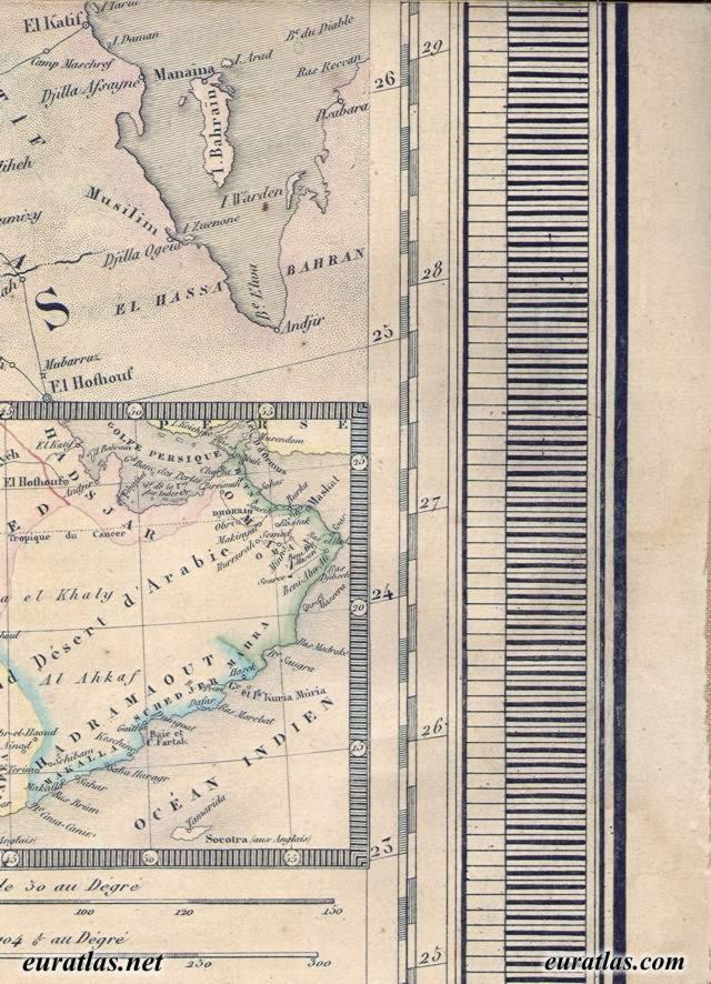
      This map, dating back to 1845.
      http://www.euratlas.net/cartogra/ottoman_1845/images/ottoman_12_7.jpg


      The following can be observed:

      • A much more accurate description of the shores of the gulf.
        • Tarout Island is correctly drawn at the heart of the Tarout Bay.
        • Half-Moon Bay is accurately mapped.
      • Roads leading to Qatif & Hoffuf are marked with stops.
      • This is evidence that the Egyptian campaign must have influenced the knowledge of the roads leading to these oases.
      • The appearance of clear demarcation of Qatar and other towns in the region is indicative of the change in the political landscape during the last century (1750 to 1840). Political changes include
        •  The rise of the Wahabbi-Saudi alliance, and expansion in their dominion.
        • The influx of powerful Najdi Arabian tribes in the middle of the 18th century to the shores of the Gulf, eagerly stepping into the power vacuum that resulted from the waning Persian Safavid Empire.
        • Namely, the migration of the descendants of the Bani Utbah tribe which started in 1744, the same year in which Muhammad ibn ʿAbd al-Wahhab concluded a pact with  Muhammad bin Saud, marking the beginning of the Wahhabi movement.
          • The contemporary ruling monarchs in Kuwait and Bahrain (who notably rejected Wahhabism) are the most notable descendants of the migration of Bani Utbah.
        • This migration changed the political and the social fabric of the region. Marking the start of the continuing decline of the oases of Qatif and Hasa, and their sphere of influence in the Arabian Gulf.